Alexander the Great,1 having completed the subjugation of Bactria, resolved to execute his cherished purpose of emulating and surpassing the mythical exploits of Dionysos, Herakles, and Semiramis by effecting the conquest of India. Towards the close of spring in the year 327 b. c., when the sun had sufficiently melted the snows, he led his army, including perhaps fifty or sixty thousand Europeans, across the lofty Khāwak and Kaoshān passes of the Hindū Kush, or Indian Caucasus, and after ten days’ toil amidst the mountains emerged in the rich valley now known as the Koh-i-Dāman.2
Here, two years earlier, before the Bactrian campaign, he had founded a town, named as usual, Alexandria, as a strategical outpost to secure his intended advance. The governor of this town, whose administration had been a failure, was replaced by Nikanor, son of Parmenion, the king’s intimate friend; the population was recruited by fresh settlers from the surrounding districts; and the garrison was strengthened by a reinforcement of veterans discharged from the ranks of the expeditionary force as being unequal to the arduous labours of the coming campaign.3
The important position of Alexandria, which commanded the roads over three passes, having been thus secured, in accordance with Alexander’s customary caution, the civil administration of the country between the passes and the Kophēn, or Kābul, river was provided for by the appointment of Tyriaspes as satrap. Alexander, when assured that his communications were safe, advanced with his army to a city named Nikaia, situated to the west of the modern Jalālābād, on the road from Kābul to India.1
Here the king divided his forces. Generals Hephaistion and Perdikkas were ordered to proceed in advance with three brigades of infantry, half of the horse guards, and the whole of the mercenary cavalry direct to India. They were required to reach the Indus, and occupy Peukelaōtis,2 situated in the territory now held by the Yusufzī. In all probability they marched along the valley of the Kābul river, and not through the Khyber Pass. Their instructions were couched in the spirit of the Roman maxim—‘Parcere subiectis et debellare superbos’.3
Most of the tribal chiefs preferred the alternative of submission, but one named Hasti (Astēs) ventured to resist. His stronghold, which held out for thirty days, was taken and destroyed. During this march eastward, Hephaistion and Perdikkas were accompanied by the king of Taxila, a great city beyond the Indus, who had lost no time in obeying Alexander’s summons, and in placing his services at the disposal of the invader. Other chiefs on the western side of the Indus adopted the same course, and, with the help of these native potentates, the Macedonian generals were enabled to make satisfactory progress in the task of bridging the Indus, which had been committed to them by their sovereign.
Alexander in person assumed the command of the second corps or division, consisting of the infantry known as hypaspists, the foot guards, the Agrianian or Thracian light infantry, the archers, the mounted lancers, and the rest of the horse guards. With this force he undertook a flanking movement through the difficult hill country north of the Kābul river, in order to subdue the fierce tribes which inhabited, as they still inhabit, that region ; and thus to secure his communications, and protect his army from attacks on the flank and rear. The difficulties of the operation due to the ruggedness of the country, the fierce heat of summer, the bitter cold of winter, and the martial spirit of the hillmen, were enormous ; but no difficulties could daunt the courage or defeat the skill of Alexander.1
Although it is absolutely impossible to trace his movements with precision, or to identify with even approximate certainty the tribes which he encountered, or the strongholds which he captured and destroyed in the course of some five months’ laborious marching ; it is certain that he ascended the valley of the Kūnar or Chitrāl river for a considerable distance. At a nameless town in the hills, Alexander was wounded in the shoulder by a dart; and the incident so enraged his troops that all the prisoners taken there were massacred, and the town was razed to the ground.1
Soon after this tragedy, Alexander again divided his forces, leaving Krateros, ‘the man most faithful to him, and whom he valued equally with himself2’, to complete the reduction of the tribesmen of the Kūnar valley; while the king in person led a body of picked troops against the Aspasians, who were defeated with great slaughter.
He then crossed the mountains and entered the valley now called Bājaur, where he found a town named Arigaion, which had been burnt and abandoned by the inhabitants. It may have stood at or near the position of Nawagai, the present chief town of Bājaur.3 Krateros, having completely executed his task in the Kūnar valley, now rejoined his master; and measures were concerted for the reduction of the tribes further east, whose subjugation was indispensable before an advance into India could be made with safety.
The Aspasians were finally routed in a second great battle, losing, it is said, more than 40,000 prisoners, and 230,000 oxen. The perfection of the arrangements by which Alexander maintained communication with his remote European base is strikingly illustrated by the fact that he selected the best and handsomest of the captured cattle, and sent them to Macedonia for use in agriculture.
A fancied connexion with Dionysos and the sacred Mount Nysa of Greek legend gave special interest to the town and hill-state called Nysa, which was among the places next attacked.1 An attempt to take the town by assault having failed by reason of the depth of the protecting river, Alexander was preparing to reduce it by blockade when the speedy submission of the inhabitants rendered further operations unnecessary. They are alleged to have craved his clemency on the ground that they were akin to Dionysos and the Greeks, because the ivy and vine grew in their country, and the triple-peaked mountain which overshadowed their town was no other than Mount Mēros. Alexander, who found such fancies useful as a stimulant to his home-sick troops, did not examine the evidence for the kinship with Dionysos in too critical a spirit, but was glad to accept the Nysaean appeals and to exercise a gracious clemency.
In order to gratify his own curiosity, and to give some of his best troops a pleasant holiday, he paid a visit to the mountain, probably that now known as the Koh-i-Mōr, accompanied by an adequate escort of the companion cavalry and foot guards. The chants and dances of the natives, the ancestors of the Kāfirs of the present day, bore sufficient resemblance to the Bacchanalian rites of Hellas to justify the claims made by the Nysaeans, and to encourage the soldiers in their belief that, although far from home, they had at last found a people who shared their religion and might be regarded as kinsmen. Alexander humoured the convenient delusion and allowed his troops to enjoy, with the help of their native friends, a ten days' revel in the jungles. The Nysaeans, on their part, showed their gratitude for the clemency which they had experienced by contributing a contingent of three hundred horsemen, who remained with Alexander throughout the whole period of his advance and were not sent home until October, 326 B. C., when he was about to start on his voyage down the rivers to the sea.2
Alexander now undertook in person the reduction of the formidable nation called the Assakēnoi, who were reported to await him with an army of 20,000 cavalry, more than 30,000 infantry, and thirty elephants. Quitting the Bājaur territory, Alexander crossed the Gouraios (Panjkora) river, with a body of picked regiments, including, as usual, a large proportion of mounted troops, and entered the Assakenian territory, in order to attack Massaga, the greatest city of those parts and the seat of the sovereign power. This formidable fortress, probably situated not very far to the north of the Malakand Pass, but not yet precisely identified, was strongly fortified by both nature and art.1 On the east, an impetuous mountain stream, flowing between steep banks, barred access; while, on the south and west, gigantic rocks, deep chasms, and treacherous morasses impeded the approach of an assailing force. Where nature failed to give adequate protection, art had stepped in, and had girdled the city with a mighty rampart, built of brick, stone, and timber, about four miles (35 stadia) in circumference, and guarded by a deep moat (Q. Curtius, viii, 10). While reconnoitring these formidable defences, and considering his plan of attack, Alexander was again wounded by an arrow. The wound was not very serious, and did not prevent him from continuing the active supervision of the siege operations, which were designed and controlled throughout by his master mind.
Commanded by such a general the meanest soldier becomes a hero. The troops laboured with such zeal that within nine days they had raised a mole level with the ground sufficient to bridge the moat, and to allow the movable towers and other engines to approach the walls. The garrison was disheartened by the death of their chief, who was killed by a blow from a missile discharged by an engine, and the place was taken by storm. Kleophis, the consort of the slain chieftain, and her infant son were captured, and it is said that she subsequently bore a son to Alexander.1
The garrison of Massaga had included a body of 7,000 mercenary troops from the plains of India. Alexander, by a special agreement, had granted these men their lives on condition that they should change sides and take service in his ranks. In pursuance of this agreement, they were allowed to retire and encamp on a small hill facing, and about nine miles (80 stadia) distant from, the Macedonian camp. The mercenaries, being unwilling to aid the foreigner in the subjugation of their countrymen, desired to evade the unwelcome obligation which they had incurred, and proposed to slip away by night and return to their homes. Alexander, having received information of their design, suddenly attacked the Indians while they reposed in fancied security and inflicted severe loss upon them. Recovering from their surprise, the mercenaries formed themselves into a hollow circle, with the women and children in the centre, and offered a desperate resistance, in which the women took an active part. At last, the gallant defenders were overpowered by superior numbers, and, in the words of an ancient historian, ‘met a glorious death which they would have disdained to exchange for a life with dishonour.’ The unarmed camp followers and the women were spared.1
This incident, which has been severely condemned by various writers, ancient and modern, as a disgraceful breach of faith by Alexander, does not seem to have been, as supposed by Diodorus, the outcome of implacable enmity felt by the king against the mercenaries. The slaughter of the contingent was rather, as represented by Arrian, the tremendous penalty for a meditated breach of faith on the part of the Indians, and, if this explanation be true, the penalty cannot be regarded as altogether undeserved. While the accession of seven thousand brave and disciplined troops would have been a welcome addition to Alexander’s small army, the addition of such a force to the enemy in the plains would have been a serious impediment to his advance; and he was, I think, justified in protecting himself against such a formidable increase of the enemy’s strength.
Alexander next captured a town called Ora or Nora, and occupied an important place named Bazira, the inhabitants of which, with those of other towns, had retired to the stronghold of Aornos near the Indus.2 The desire of Alexander to capture this position, believed to be impregnable, was based upon military exigencies, and fired by a legend that the demi-god, Herakles, whom he claimed as an ancestor, had been baffled by the defences.
The mountain, according to Diodorus, was washed on the southern face by the Indus, the greatest of Indian rivers, which at this point was very deep, and enclosed by rugged and precipitous rocks, forbidding approach from that side. On the other sides, as at Massaga, ravines, cliffs, and swamps presented obstacles sufficient to daunt the bravest assailant. Arrian states that a single path gave access to the summit, which was well supplied with water, and comprised arable land requiring the labour of a thousand men for its cultivation. The summit was crowned by a steeply scarped mass of rock, which formed a natural citadel, and, doubtless, was further protected by art.1
Before undertaking the siege of this formidable stronghold, Alexander with his habitual foresight, secured his rear by placing garrisons in the towns of Ora, Massaga, Bazira, and Orobatis, in the hills of Suwāt and Bunēr.
He further isolated the fortress by personally marching down into the plains, probably through the Shāhkōt Pass,1 and receiving the submission of the important city of Peukelaōtis (Chārsadda), and the surrounding territory, now known as the Yusufzī country. During this operation he was assisted by two local chiefs. He then made his way somehow to Embolima, a small town on the Indus, at the foot of Aornos, and there established a dépôt under the command of Krateros. In case the assault should fail, and the siege be converted into a blockade, this dépôt was intended to serve as a base for protracted operations should such prove to be necessary.
Having thus deliberately made his dispositions for the siege, Alexander spent two days in careful personal reconnaissance of the position with the aid of a small force, chiefly consisting of light-armed troops. Assisted by local guides, whose services were secured by liberal reward, Ptolemy, the son of Lagos, secured a valuable foothold on the eastern spur of the mountain, where he entrenched his men. An attempt made by the king to support him having been frustrated, this failure led to a vigorous attack by the Indians on Ptolemy's entrenchments, which was repulsed after a hard fight.
A second effort made by Alexander to effect a junction with his lieutenant, although stoutly opposed by the besieged, was successful; and the Macedonians were now in secure possession of the vantage-ground from which an assault on the natural citadel could be delivered.
The task before the assailants was an arduous one, for the crowning mass of rock did not, like most eminences, slope gradually to the summit, but rose abruptly in the form of a steep cone. Examination of the ground showed that a direct attack was impossible until some of the surrounding ravines should be filled up. Plenty of timber being available in the adjoining forests, Alexander resolved to use this material to form a pathway. He himself threw the first trunk into the ravine, and his act was greeted with a loud cheer signifying the keenness of the troops, who could not shrink from any labour, however severe, to which their king was the first to put his hand.
Within the brief space of four days Alexander succeeded in gaining possession of a small hill on a level with the rock, and in thus securing a dominant position. The success of this operation convinced the garrison that the capture of the citadel was merely a question of time, and negotiations for capitulation on terms were begun.
The besieged, being more anxious to gain time for escape than to conclude a treaty, evacuated the rock during the night, and attempted to slip away unobserved in the darkness. But the unsleeping vigilance of Alexander detected the movement, and partially defeated their plans. Placing himself at the head of 700 picked men, he clambered up the cliff the moment the garrison began to retire and slew many.
In this way the virgin fortress, which even Herakles had failed to win, became the prize of Alexander. The king, justly proud of his success, offered sacrifice and worship to the gods, dedicated altars to Athēnē and Nikē, and built a fort for the accommodation of the garrison which he quartered on the mountain. The command of this important post was entrusted to Sisikottos (Sasigupta), a Hindu, who long before had deserted from the Indian contingent attached to the army of Bessus, the rebel satrap of Bactria, and had since proved himself a faithful officer in the Macedonian service.
Alexander then proceeded to complete the subjugation of the Assakenians by another raid into their country, and occupied a town named Dyrta, which probably lay to the north of Aornos. This town and the surrounding district were abandoned by the inhabitants, who had crossed the Indus, and taken refuge in the Abhisāra country, in the hills between the Hydaspes (Jihlam) and Akesinēs (Chināb) rivers.1 He then slowly forced his way through the forests down to the bridge-head at Ohind. Although the direct distance could not be great, the work of clearing a road passable for an army was so arduous that fifteen or sixteen marches were required to reach Hephaestion's camp.1
Opinions have differed concerning the location of the bridge over the Indus, and most writers have been inclined to place it at Attock (Atak), where the river is narrowest. But the investigations of M. Foucher have clearly established the fact that the bridge, presumably constructed of boats, must have been at Ohind or Und, 16 miles above Attock.
Having arrived at the bridge-head, Alexander sacrificed to the gods on a magnificent scale, and gave his army thirty days of much needed rest, amusing them with games and gymnastic contests.2
At Ohind Alexander was met by an embassy from Ambhi (Omphis),3 who had then succeeded to the throne of Taxila, the great city three marches beyond the Indus. The lately deceased king had met the invader in the previous year at Nikaia and tendered the submission of his kingdom. This tender was now renewed on behalf of his son by the embassy, and was supported by a contingent of 700 horse and the gift of valuable supplies comprising thirty elephants, 3,000 fat oxen, more than 10,000 sheep, and 200 talents of silver.
The ready submission of the rulers of Taxila is explained by the fact that they desired Alexander’s help against their enemies in the neighbouring states. At that moment Taxila was at war both with the hill kingdom of Abhisāra, and with the more powerful state governed by the king whom the Greeks called Pōros, approximately coincident with the modern districts of Jihlam, Gujarāt, and Shāhpur.1
Spring had now begun, and the omens being favourable the refreshed army began the passage of the river one morning at daybreak; and, with the help of the Taxilan king, safely effected entrance on the soil of India, which no European traveller or invader had ever before trodden.2
A curious incident marked the last day’s march to Taxila. When four or five miles from the city Alexander was startled to see a complete army in order of battle advancing to meet him. He supposed that treacherous opposition was about to be offered, and had begun to make arrangements to attack the Indians, when Āmbhi galloped forward with a few attendants and explained that the display of force was intended as an honour, and that his entire army was at Alexander’s disposal. When the misunderstanding had been removed the Macedonian force continued its advance and was entertained at the city with royal magnificence.
Taxila, now represented by more than twelve square miles of ruins to the east and north-east of Sarai-Kala, a railway-junction twenty miles north-west of Rāwalpindī, was then one of the greatest cities of the east, and was famous as the principal seat of Hindu learning in Northern India, to which scholars of all classes flocked for instruction, especially in the medical sciences.1
Āmbhi recognized Alexander as his lord, and received from him investiture as lawful successor of his deceased father the king of Taxila. In return for the favour shown to him by the invader, he provided the Macedonian army with liberal supplies, and presented Alexander with two hundred talents of coined silver,1 ‘three thousand oxen fatted for the shambles’, ten thousand or more sheep, and thirty elephants.2 Alexander, not to be outdone in generosity, bestowed on the donor a thousand talents from the spoils of war, along with many banqueting vessels of gold and silver, a vast quantity of Persian drapery, and thirty chargers caparisoned as when ridden by himself. This lavish generosity, although displeasing to Alexander’s Macedonian officers, probably was prompted more by policy than by sentiment. It purchased a contingent of 5,000 men, and secured the fidelity of a most useful ally (Q. Curtius, viii, 12; Diodorus, xvii, 86; Arrian, v, 8).
While Alexander was at Taxila, the hill chieftain of Abhisāra, who really intended to join Pōros in repelling the invader (Diodorus, xvii, 87), sent envoys who professed to surrender to Alexander all that their master possessed. This mission was favourably received, and Alexander hoped that Pōros would display complaisance equal to that of his ally. But a summons sent requiring him to do homage and pay tribute was met with the proud answer that he would indeed come to his frontier to meet the invader, but at the head of an army ready for battle.
Having stayed in his comfortable quarters at Taxila for sufficient time to rest his army (Diodorus, xvii, 87), Alexander led his forces, now strengthened by the Taxilan contingent and a small number of elephants, eastward to meet Pōros, who was known to be awaiting him on the farther bank of the Hydaspes (Jihlam) river. The march from Taxila to Jihlam on the Hydaspes, in a south-easterly direction, a distance of about 100 or 110 miles, according to the route followed, brought the army over difficult ground and probably occupied a fortnight.1 The hot season was at its height, but to Alexander all seasons were equally fit for campaigning, and he led his soldiers on and on from conquest to conquest, regardless of the snows of the mountains and the scorching heat of the plains. He arrived at Jihlam early in May, and found the river already flooded by the melting of the snow in the hills. The boats which had served for the passage of the Indus, having been cut into sections and transported on wagons to be rebuilt on the banks of the Hydaspes, were again utilized for the crossing of that river (Arrian, v, 8).
In spite of the most elaborate preparations, the problem of the passage of the Hydaspes in the face of a superior force could not be solved without minute local knowledge; and Alexander was compelled to defer his decision as to the best feasible solution until he should have acquired the necessary acquaintance with all the local conditions. On his arrival he found the army of Pōros, fifty thousand strong, drawn up on the opposite bank. It was obvious that the horses of the cavalry, the arm upon which the Macedonian commander placed his reliance, could not be induced to clamber up the bank of a flooded river in the face of a host of elephants, and that some device for evading this difficulty must be sought.
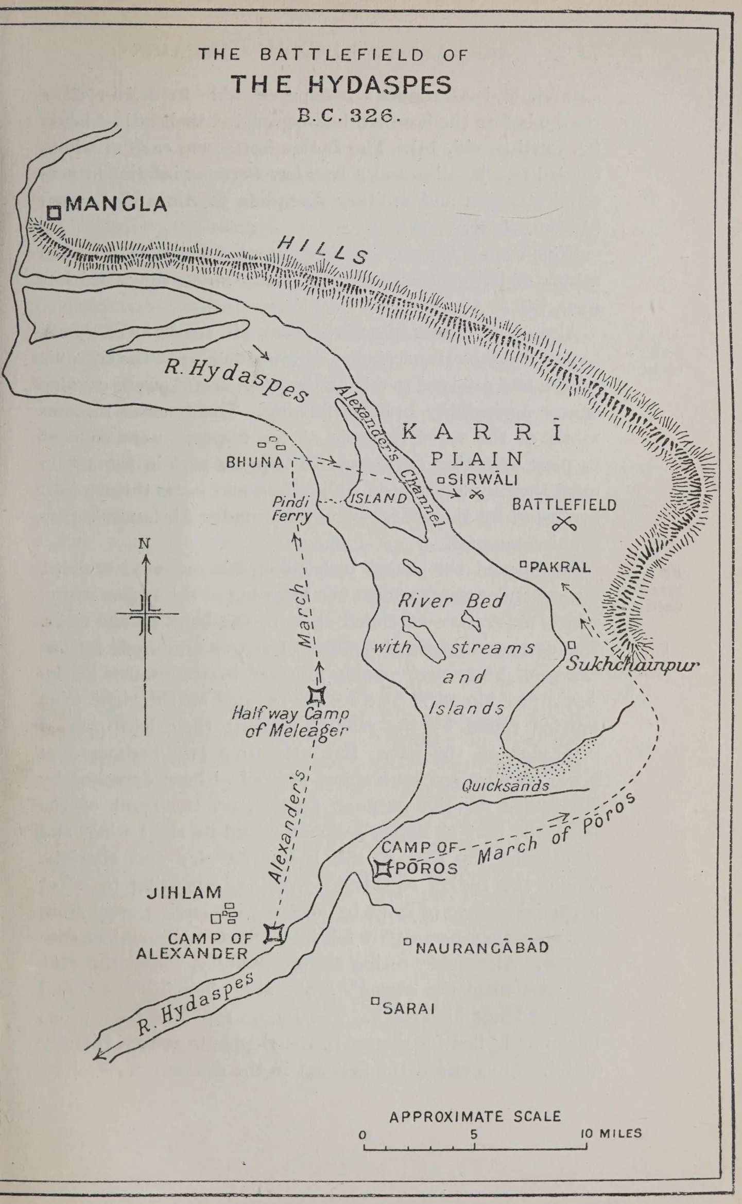
Alexander, therefore, resolved, in the words of Arrian, to ‘steal a passage’. The easiest plan would have been for the invader to wait patiently in his lines until October or November, when the waters would subside and the river might become fordable. Although such dilatory tactics did not commend themselves to the impetuous spirit of Alexander, he endeavoured to lull the vigilance of the enemy by the public announcement that he intended to await the change of season, and gave a colour of truth to the declaration by employing his troops in foraging expeditions and the collection of a great store of provisions. At the same time his flotilla of boats continually moved up and down the river, and frequent reconnaissances were made in search of a ford. ‘All this,’ as Arrian observes, ‘prevented Pōros from resting and concentrating his preparations at any one point selected in preference to any other as the best for defending the passage’ (v, 9). Rafts, galleys, and smaller boats were secretly prepared and hidden away among the woods and islands in the upper reaches of the river. These preliminaries occupied six or seven weeks, during which time the rains had broken, and the violence of the flood had increased. Careful study of the ground had convinced Alexander that the best chance of crossing in safety was to be found near a sharp bend in the river about 16 miles marching distance above his camp, at a point where his embarkation would be concealed by a bluff and an island covered with forest. Having arrived at this decision, Alexander acted upon it, not only, as Arrian justly remarks, with ‘marvellous audacity’, but with consummate prudence and precaution.
He left Krateros with a considerable force, including the Taxilan contingent of 5,000 men, to guard the camp near Jihlam, and supplied him with precise instructions as to the manner in which he should use this reserve force to support the main attack. Half-way between the standing camp and the chosen crossing-place three generals were stationed with the mercenary cavalry and infantry, and had orders to cross the river as soon as they should perceive the Indians to be fairly engaged in action. All sections of the army were kept in touch by a chain of sentries posted along the bank.
When all these precautionary arrangements had been completed, Alexander in person took command of a picked force of about 11,000 or 12,000 men, including the foot guards, hypaspist infantry, mounted archers, and 5,000 cavalry of various kinds, with which to effect the passage. In order to escape observation, he marched by night at some distance from the bank, and his movements were further concealed by a violent storm of rain and thunder which broke during the march. He arrived unperceived at the appointed place and found the fleet of galleys, boats, and rafts in readiness. The enemy had no suspicion of what was happening until the fleet appeared in the open river beyond the wooded island, and Alexander disembarked his force at daybreak without opposition. But when he had landed, he was disappointed to find that yet another deep channel lay in front, which must be crossed. With much difficulty a ford was found, and the infantry struggled through breast deep in the stream, while the horses swam with only their heads above water. The sole practicable road from the camp of Pōros involved a wide détour, which rendered prompt opposition impossible, and Alexander was able to deploy his dripping troops on the mainland before any attempt could be made to stop him.
Then, when it was too late, the son of the Indian king came hurrying up with 2,000 horse and 120 chariots. This inadequate force was speedily routed with the loss of 400 killed, and of all the chariots. Fugitives carried the disastrous news to the camp of Pōros, who moved out with the bulk of his army to give battle, leaving a guard to protect his baggage against Krateros, who lay in wait on the opposite bank. The Indian army deployed on the only ground available, the plain now known as Karrī, girdled on the north and east by low hills, and about 5 miles in width at its broadest part. The surface was a firm sandy soil well adapted for military movements even in the rainy season.
A stately force it was with which the Indian monarch moved forth to defend his country against the audacious invader from the west. Two hundred huge elephants, stationed at intervals of not less than a hundred feet from one another, and probably in eight ranks, formed the front in the centre.1 The chief reliance of Pōros was on these monsters who would, it was calculated, terrify the foreign soldiers and render the dreaded cavalry unmanageable. Behind the elephants stood a compact force of 30,000 infantry with projections on the wings, and files of the infantry were pushed forward in the intervals between the elephants, so that the Indian army presented ‘very much the appearance of a city—the elephants as they stood resembling its towers, and the men-at-arms placed between them resembling the lines of wall intervening between tower and tower’ (Diodorus, xvii, 87). Both flanks were protected by cavalry with chariots in front. The cavalry numbered 4,000 and the chariots 300. Each chariot was drawn by four horses, and carried six men, of whom two were archers, stationed one on each side of the vehicle, two were shield-bearers, and two were charioteers, who in the stress of battle were wont to drop the reins and ply the enemy with darts (Q. Curtius, viii, 14).
The infantry were all armed with a broad and heavy two-handed sword suspended from the left shoulder,2 and a long buckler of undressed ox-hide. In addition to these arms each man carried either javelins or a bow. The bow is described as being
‘made of equal length with the man who bears it. This they rest upon the ground, and pressing against it with their left foot thus discharge the arrow having drawn the string backwards: for the shaft they use is little short of being three yards long, and there is nothing which can resist an Indian archer’s shot—neither shield nor breastplate, nor any stronger defence, if such there be’ (Arrian, Indika, ch. xvi).
But great as was the power of the Indian bow, it was too cumbrous to meet the attack of the mobile Macedonian cavalry. The slippery state of the surface prevented the archers from resting the end of their weapons firmly on the ground, and Alexander’s horse were able to deliver their charge before the bowmen had completed their adjustments (Q. Curtius, viii, 14). The Indian horsemen, each of whom carried two javelins and a buckler, were far inferior in personal strength and military discipline to Alexander’s men (Arrian, Anab. v, 17).
With such a force and such equipment Pōros awaited the attack of the greatest military genius whom the world has seen.
Alexander clearly perceived that his small force would have no chance of success in a direct attack upon the enemy’s centre, and resolved to rely on the effect of a vigorous cavalry charge against the Indian left wing. The generals in command of the 6,000 infantry at his disposal were ordered to play a waiting game, and to take no part in the action until they should see the Indian foot and horse thrown into confusion by the charge of cavalry under Alexander’s personal command.
He opened the action by sending his mounted archers, a thousand strong, against the left wing of the Indian army, which must have extended close to the bank of the river. The archers discharged a storm of arrows and made furious charges. They were quickly followed by the Guards led by Alexander himself. The Indian cavalry on the right wing hurried round by the rear to support their hard-pressed comrades on the left. But meantime two regiments of horse commanded by Koinos, which had been detached by Alexander for the purpose, swept past the front of the immobile host of Pōros, galloped round its right wing, and threatened the rear of the Indian cavalry and chariots. While the Indian squadrons were endeavouring to effect a partial change of front to meet the impending onset from the rear, they necessarily fell into a certain amount of confusion. Alexander, seeing his opportunity, seized the very moment when the enemy’s horse were changing front, and pressed home his attack. The Indian ranks on both wings broke and ‘fled for shelter to the elephants as to a friendly wall’. Thus ended the first act in the drama.
The elephant drivers tried to retrieve the disaster by urging their mounts against the Macedonian horse, but the phalanx, which had now advanced, began to take its deferred share in the conflict. The Macedonian soldiers hurled showers of darts at the elephants and their riders. The maddened beasts charged and crushed through the closed ranks of the phalanx, impenetrable to merely human attack. The Indian horsemen seized the critical moment, and, seeking to revenge the defeat which they had suffered in the first stage of the action, wheeled round and attacked Alexander’s cavalry. But the Indians were not equal to the task which they attempted, and being repulsed, were again cooped up among the elephants. The second act of the drama was now finished.
The third and last began with a charge by the Macedonian massed cavalry which crashed into the broken Indian ranks and effected an awful carnage. The battle ended at the eighth hour of the day (Plutarch, Life, ch. 60) in a scene of murderous confusion, which is best described in the words of Arrian, whose account is based on that of men who shared in the fight.
‘The elephants, he writes, ‘being now cooped up within a narrow space, did no less damage to their friends than to their foes, trampling them under their feet as they wheeled and pushed about. There resulted in consequence a great slaughter of the cavalry, cooped up as it was within a narrow space around the elephants. Many of the elephant drivers, moreover, had been shot down, and of the elephants themselves some had been wounded, while others, both from exhaustion and the loss of their mahouts, no longer kept to their own side of the conflict, but, as if driven frantic by their sufferings, attacked friend and foe quite indiscriminately, pushed them, trampled them down, and killed them in all manner of ways. But the Macedonians, who had a wide and open field, and could therefore operate as they thought best, gave way when the elephants charged, and when they retreated followed at their heels and plied them with darts; whereas the Indians, who were in the midst of the animals, suffered far more from the effects of their rage.
‘When the elephants, however, became quite exhausted, and their attacks were no longer made with vigour, they fell back like ships backing water, and merely kept trumpeting as they retreated with their faces to the enemy. Then did Alexander surround with his cavalry the whole of the enemy’s line, and signal that the infantry, with their shields linked together so as to give the utmost compactness to their ranks, should advance in phalanx. By this means the cavalry of the Indians was, with a few exceptions, cut to pieces in the action. Such also was the fate of the infantry, since the Macedonians were now pressing them from every side. ‘Upon this all turned to flight wherever a gap could be found in the cordon of Alexander’s cavalry.’
Meanwhile, Krateros and the other officers left on the opposite bank of the river had crossed over, and with their fresh troops fell upon the fugitives, and wrought terrible slaughter. The Indian army was annihilated; all the elephants being either killed or captured, and the chariots destroyed. Three thousand horsemen, and not less than twelve thousand foot soldiers were killed, and 9,000 taken prisoners. The Macedonian loss, according to the highest estimate, did not exceed a thousand.
Pōros himself, a magnificent giant, six and a half feet in height, fought to the last, but at last succumbed to nine wounds, and was taken prisoner in a fainting condition.
Alexander had the magnanimity to respect his gallant adversary, and willingly responded to his proud request to be ‘treated as a king1’. The victor not only confirmed the vanquished prince in the government of his ancestral territory, but added to it other lands of still greater extent; and by this politic generosity secured for the brief period of his stay in the country a grateful and faithful friend.2
The victory was commemorated by the foundation of two towns; one named Nikaia, situated on the battlefield; and the other, named Boukephala, situated at the point whence Alexander had started to cross the Hydaspes. The latter was dedicated to the memory of Alexander’s famous charger, which had carried him safely through so many perils, and had now at last succumbed to weariness and old age. Boukephala, by reason of its position at a ferry on the high road from the west to the Indian interior, became a place of such fame and importance as to be reckoned by Plutarch among the greatest of Alexander’s foundations. It was practically identical with the modern town of Jihlam (Jhelum), and its position is more closely marked by the extensive elevated mound to the west of the existing town.
The position of Nikaia, which never attained fame, is less certain; but probably should be sought at the village of Sukhchainpur to the south of the Karrī plain, the scene of the battle.1
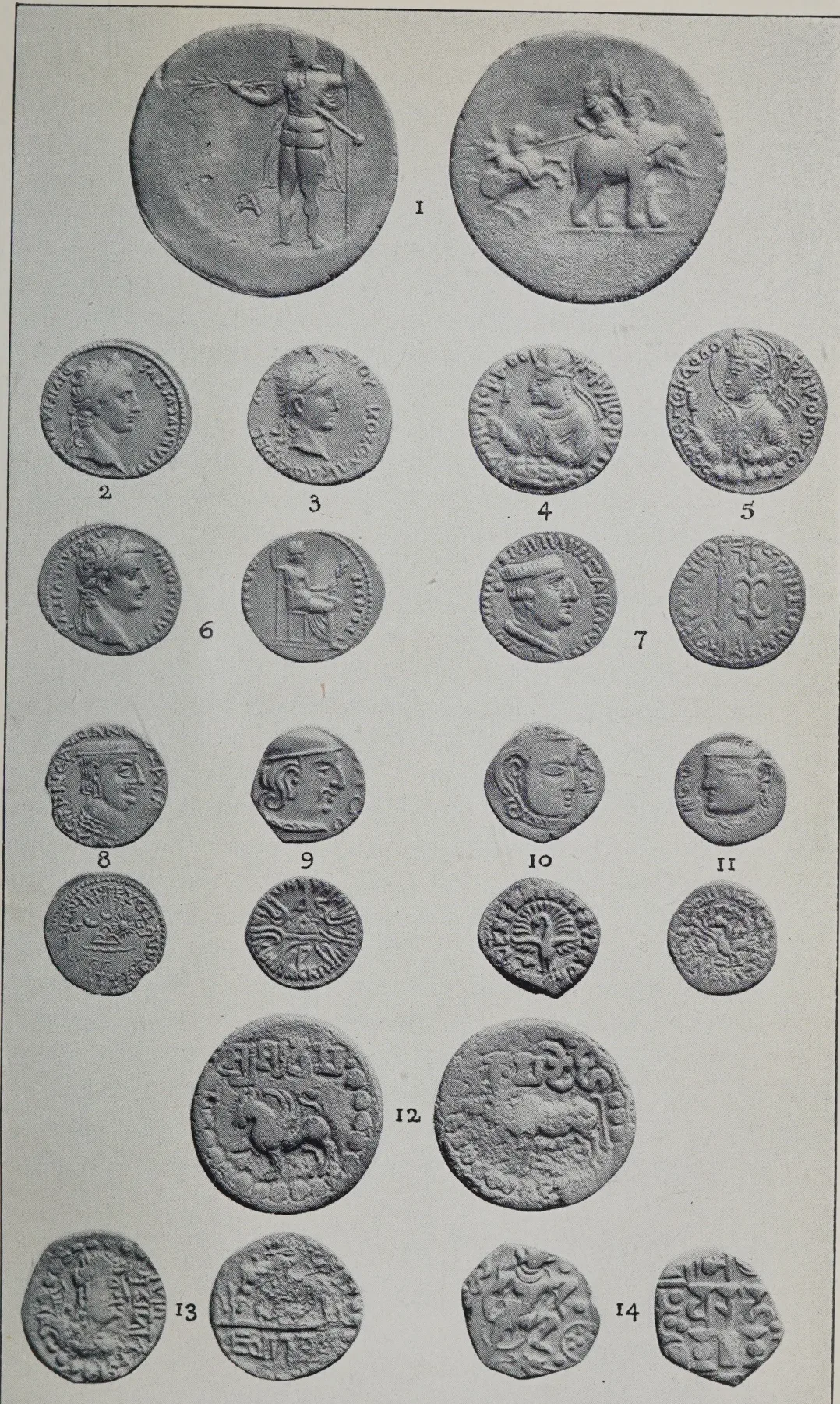
An interesting numismatic memorial of the battle is the famous unique dekadrachm in the British Museum, ‘showing on one side a Macedonian horseman driving before him a retreating elephant with its two riders, and on the other side a standing figure of Alexander holding a thunderbolt, and wearing the Persian helmet, and with A (᾿Αλεξάνδρου Βασιλέως ?) in the field. Mr. Barclay Head shows good reason for believing that this piece was struck in India as a medal for presentation to Macedonian officers who took part in the battle.2
Alexander, having performed with fitting splendour the obsequies of the slain, offered the customary sacrifices, and celebrated games, left Krateros behind with a portion of the
CONTENTS OF PLATE OF INDIAN COINS AND MEDALS (2) IN THE BRITISH MUSEUM
| No. | King. | Obverse. | Reverse. | References and Remarks. |
|---|---|---|---|---|
| 1 | Alexander. | A. standing, wearing Persian helmet, and holding thunderbolt. Mon. A. | Horseman attacking elephant with riders. | Dekadrachm medal, probably struck to commemorate battle of Hydaspes. Num. Chron., 1906, p. 8, Pl. i, 8. |
| 2 | Augustus. | Head of Augustus. | . . . . | Denarius; for comparison with No. 3. |
| 3 | Kozola Kadaphes (Kadphises I). | Head of king, with legend in Greek script. | . . . . | Bronze imitation of No. 2. As Gardner, Catal., Pl. xxv, 5. |
| 4 | Huvishka. | Portrait bust of king; legend in modified Greek script. | . . . . | Gold. As Gardner, Pl. xxvii, 16. |
| 5 | Ditto. | Ditto. | . . . . | Gold. As Gardner, Pl. xxvii, 9. |
| 6 | Tiberius. | Head of Tiberius. | Emperor seated as Pontifex Maximus. | Denarius; for comparison with various Indian coins. |
| 7 | Nahapāna, Kshaharāta satrap. | Head of satrap, with modified Greek legend. | Thunderbolt and arrow. Kharoshṭhī version of Greek legend. | Rapson, B. M. Catal., No. 243. |
| 8 | Chashṭana, Śaka satrap. | Head of satrap, with modified Greek legend. | Sun, or star, moon; chaitya symbol, river or snake. Brahmī legend of titles and name. | Rapson, B. M. Catal., No. 260, &c. (=Pl. X, J. B.). |
| 9 | Rudrasiṁha, Śaka satrap. | Head of satrap, with traces of corrupt Greek legend. | Chaitya symbol. Brahmī legend of name and titles. | Rapson, B. M. Catal., Pl. xvi, No. 911. |
| 10 | Kumāragupta I. | Head of king, with date, ?119. | Fantail peacock. Brahmī legend of name and titles. | As Cunningham, A. S. Rep., vol. ix, Pl. v, 6, 7. |
| 11 | Toramāṇa Hūna. | Head of king to l., with date 52. | Fantail peacock. Brahmī legend of name and titles. | Coins, Med. India, Pl. ii. 11. |
| 12 | Aṁśuvarman of Nepāl. | Winged lion. Brahmī legend, Śry-amśurvarma. | Cow. Brahmī legend, Kāmadēhi, 'incarnation of Kāma'. | Coins, Anc. India, Pl. xiii, 6. |
| 13 | Mihiragula Hūna. | Barbarous bust of king, with name in Brahmī script. | Rude bull, walking l. Legend, jayatu vṛishah, 'victory to the bull'. | As I. M. Catal., vol. i, Pl. xxv, 5. |
| 14 | Bhoja or Mihira, Gurjara-Pratihāra, king of Kanauj. | Boar incarnation of Vishṇu, and solar symbol. | Traces of Sassanian type. Legend, imperfect, Srímad Ādi-varāha, ‘the fortunate primaeval boar’, a title of both Vishṇu and the king. | As I. M. Catal., vol. i, Pl. xxv, 18. |
army, and orders to fortify posts and maintain communications. The king himself, taking a force of picked troops, largely composed of cavalry, invaded the country of a nation called Glausai or Glaukanikoi, adjacent to the dominions of Pōros. Thirty-seven considerable towns and a multitude of villages, having readily submitted, were added to the extensive territory administered by Pōros. The king of the lower hills, who is called Abisares by the Greek writers, finding resistance hopeless, again tendered his submission. Another Pōros, nephew of the defeated monarch, and ruler of a tract called Gandaris, sent envoys promising allegiance to the invincible invader, and sundry independent tribes (τῶν αὐτονόμων Ἰνδῶν) followed the example of these princes.
Alexander, moving in a direction more easterly than before, crossed the Akesinēs (Chināb) at a point not specified, but certainly near the foot of the hills. The passage of the river, although unopposed, was difficult by reason of the rapid current of the flooded stream, which was 3,000 yards (15 stadia) in width, and of the large and jagged rocks with which the channel was bestrewn, and on which many of the boats were wrecked.1
The king, having made adequate arrangements for supplies, reinforcements, and the maintenance of communications, continued his advance eastwards, probably passing close to the ancient fortress of Siālkōt. The Hydraōtes (Rāvī) river having been crossed without difficulty, Hephaistion was sent back in order to reduce to obedience the younger Pōros, who had revolted owing to feelings of resentment at the excessive favour shown to his uncle and enemy.
Alexander selected as the adversaries worthy of his steel the more important confederacy of independent tribes2 which was headed by the Kathaioi, who dwelt upon the left or eastern side of the Hydraōtes, and enjoyed the highest reputation for skill in the art of war. Their neighbours, the Oxydrakai, who occupied the basin of the Hyphasis, and the Malloi, who were settled along the lower course of the Hydraōtes below Lahore, and were also famous as brave warriors, intended to join the tribal league, but had not actually done so at this time. The Kathaioi were now supported only by minor clans, their immediate neighbours, and the terrible fate which awaited the Malloi was postponed for a brief space.1
On the second day after the passage of the Hydraōtes, Alexander received the capitulation of a town named Pimprama, belonging to a clan called Adraïstai by Arrian; and, after a day’s rest, proceeded to invest Sangala, which the Kathaioi and the allied tribes had selected as their main stronghold. The tribes protected their camp, lying under the shelter of a low hill, by a triple row of wagons, and offered a determined resistance.
Meanwhile, the elder Pōros arrived with a reinforcement for the besiegers of five thousand troops, elephants, and a siege train; but before any breach in the city wall had been effected, the Macedonians stormed the place by escalade, and routed the allies, who lost many thousands killed. Alexander’s loss in killed was less than a hundred, but twelve hundred of his men were wounded—an unusually large proportion.
Sangala was razed to the ground, as a punishment for the stout resistance of its defenders.2
Yet another river, the Hyphasis (Bias), lay in the path of the royal adventurer, who advanced to its bank, and prepared to cross, being determined to subdue the nations beyond. These were reputed to be clans of brave agriculturists, enjoying an admirable system of aristocratic government, and occupying a fertile territory well supplied with elephants of superior size and courage.
Alexander, having noticed that his troops no longer followed him with their wonted alacrity, and were indisposed to proceed to more distant adventures, sought to rouse their enthusiasm by an eloquent address, in which he recited the glories of their wondrous conquests from the Hellespont to the Hyphasis, and promised them the dominion and riches of all Asia. But his glowing words fell on unwilling ears, and were received with painful silence, which remained unbroken for a long time.
At last Koinos, the trusted cavalry general, who had led the charge in the battle with Pōros, summoned up courage to reply, and argued the expediency of fixing some limit to the toils and dangers of the army. He urged his sovereign to remember that out of the Greeks and Macedonians who had crossed the Hellespont eight years earlier, some had been invalided home, some were unwilling exiles in newly founded cities, some were disabled by wounds, and others, the most numerous, had perished by the sword or disease.
Few indeed were those left to follow the standards; and they were weary wretches, shattered in health, ragged, ill-armed, and despondent. He concluded his oration by saying :
‘ Moderation in the midst of success, O king! is the noblest of virtues, for, although, being at the head of so brave an army, you have naught to dread from mortal foes, yet the visitations of the Deity cannot be foreseen or guarded against by man.’ 1
The words of Koinos were greeted with loud applause, which left no doubt about the temper of the men. Alexander, deeply mortified, and unwilling to yield, retired within his tent ; but emerged on the third day, convinced that further advance was impracticable. The soothsayers judiciously discovered that the omens were unfavourable for the passage of the river, and Alexander, with a heavy heart, gave orders for retreat, in September, 326 B. C.
To mark the farthest point of his advance, he erected twelve huge altars, built of squared stone, and each fifty cubits in height, dedicated to the twelve great gods. Although the army had not passed the river, these massive memorials are alleged by Pliny to have been erected on the farther, i.e. northern, bank, where they long remained to excite the wonder and veneration of both natives and foreigners.1 They probably stood at the point where the Biās flows from east to west between Indaura in the Kāngrā and Mīrthal in the Gurdāspur district, close to the foot of the hills. The cutting back of the northern bank, which has extended for about five miles, has swept away all traces of the buildings.2
The judicious Arrian simply records that :—
‘ Alexander divided the army into brigades, which he ordered to prepare twelve altars equal in height to the loftiest military towers, while exceeding them in breadth ; to serve both as thank-offerings to the gods who had led him so far on the path of conquest, and as a memorial of his achievements. When the altars had been constructed, he offered sacrifice upon them with the customary rites, and celebrated gymnastics and equestrian games.’
The structures thus solemnly dedicated were well designed to serve their double purpose; and constituted a dignified and worthy monument of the piety and labours of the world’s greatest general. Their significance was fully appreciated by the Indian powers which had been compelled to bend before the Macedonian storm. We are told that Chandragupta Maurya, the first emperor of India, who succeeded to the lordship of Alexander’s conquests, and his successors for centuries afterwards, continued to venerate the altars, and were in the habit of crossing the river to offer sacrifice upon them.1
But, if Curtius and Diodorus are to be believed, the noble simplicity of the monumental altars was marred by a ridiculous addition designed to gratify the king’s childish vanity. The tale is given in its fullest form by Diodorus, who gravely informs us that after the completion of the altars, Alexander caused an encampment to be made thrice the size of that actually occupied by his army, encircled by a trench 50 feet wide and 40 feet deep, as well as by a rampart of extraordinary dimensions. ‘He further’, the story continues, ‘ordered quarters to be constructed as for foot-soldiers, each containing two beds 4 cubits in length for each man; and besides this, two stalls of twice the ordinary size for each horseman. Whatever else was to be left behind was directed to be likewise proportionately increased in size.’ We are asked to believe that these silly proceedings were intended to convince the country people that the invaders had been men of more than ordinary strength and stature.1
It is incredible that Alexander could have been guilty of such senseless folly, and the legend may be rejected without hesitation as being probably based on distorted versions of tales told by travellers who had seen the altars.
Notes
- 1. The story of Alexander’s reign prior to the Indian expedition may be read best in Bury, A History of Greece (Macmillan, 1904). The statement of Plutarch (Alexander, ch. lxvi) that his hero entered India with 120,000 foot and 15,000 horse may or may not be correct, and is open to much variety of interpretation.
- 2. ’Εξήκοντος ἤδη τοῦ ἦρος (Arrian); i. e. late in April, or early in May. For identification of the passes see Holdich, Report of the Pāmir Boundary Commission, pp. 29, 30. The height of the Khāwak Pass, as marked on the India Office map of India, is 13,200 feet. The strength of the force that crossed the Hindū Kush is not known.
- 3. Alexandria ‘under the Caucasus’, or ‘in the Paropanisadai’, to distinguish it from the numerous other towns of the same name. The exact position cannot be determined, but its site may be marked by the extensive ruins at Opiān or Houpiān, near Chārikar, some thirty miles northward from [p. 53] Kābul. The old identification with Bāmiān is certainly erroneous (McCrindle, Invasion of India by Alexander the Great, 2nd ed., p. 58, and note A ; Cunningham, Anc. Geog. India, pp. 21–6). Von Schwarz identifies Alexandria in the Paropanisadai with Kābul (Alexander des Grossen Feldzüge in Turkestan, pp. 94, 101, 102).
- 1. The rival opinions concerning the site of Nikaia are collected by McCrindle (op. cit. note B). I follow General Abbot, who was clearly right, as Jalālābād marks the spot where the division of the army would naturally take place. Certain local chiefs, the Sultans of Pīch, claim descent from Alexander (Raverty, Notes on Afghanistan, pp. 48–51). See Burnes, Travels into Bokhara, &c., 2nd ed., 1835, vol. iii, pp. 186–90. The other claimants to descent from Alexander are :—(1) the former Mīrs of Badakshan, superseded by a Turk dynasty about 1822 ; (2–5) the chiefs of Darwāz, Kulāb, Shighnān, and Wakhan ; and (6–8) the chiefs of Chitrāl, Gilgit and Iskardo. The last-named fort is said to have been built by Alexander. The Tungani soldiers who garrisoned Yarkand in 1835, also claimed descent from Alexander’s soldier colonists.
- 2. Or Πευκελαῖτις. Grierson holds that this name and other Greek transliterations are from Paiśāchī Prākrit (Ind. Ant., 1915, p. 228).
- 3. The ancient road did not pass through the Khaibar (Khyber) Pass (Holdich, The Indian Borderland, 1901, p. 38) ; Foucher, Notes sur la géographie ancienne du Gandhāra (Hanoi, 1902, in Bull. de l’École Fr. d’Extrême-Orient). The Khaibar route probably was used once by Mahmūd of Ghaznī, and certainly several times by Bābur and Humāyun. In the eighteenth century, Nādir Shāh, Ahmad Shāh Abdālī, and his grandson, Shāh-i-Zamān, all passed through the Khaibar (Raverty, Notes, pp. 38, 73).
- 1. ᾿Αλλ᾿ οὔτε χειμὼν ἐγένετο ἐμποδὼν αὐτῷ οὔτε αἱ δυσχωρίαι . . . οὐδὲν ἄπορον ᾿Αλεξάνδρῳ τῶν πολεμικῶν ἦν ἐς ὅ, τι ὁρμήσειε (Arrian, Anab. vii, 15). Similar precautions were not of march, because the hills there have ‘ never afforded suitable ground for the collection of fighting bodies of men in any great strength ’ (Holdich, The Gates of India, p. 95).
- 1. A list of very speculative identifications of tribes and places will be found in Bellew’s Ethnography of Afghanistan, pp. 64–76 (Woking, 1891). The guesses of Cunningham and other writers are equally unsatisfactory. I do not agree with Pincott that Alexander went as far north as Chitrāl (J. R. A. S., 1894, p. 681); but at present it is not possible to determine the point at which he turned eastwards, and crossed the mountains into Bājaur. It is, however, certain that he used one of the regular passes, which necessarily remain unchanged, and by which alone Bājaur territory can be entered. Raverty describes, from native information, two routes from Kābul to Bājaur; and it may well be that Alexander followed the ‘left-hand’, or eastern one, which goes through a village named Kūz Danāhi, where two roads diverge, of which one leads to Chitrāl, and the other to the Shahr, or capital of Bājaur (Notes, pp. 112–18).
- 2. Arrian, Anab. vii, 12.
- 3. Holdich, The Gates of India, 1910, p. 103.
- 1. Curtius (viii, 10), places the surrender of Nysa before the siege of Massaga.
- 2. Arrian, Anab. v, 1, vi, 2; Curtius, viii, 10; Justin, xii, 7; Plutarch, Alex., ch. lviii; Strabo, xv, 7–9. The conjectures concerning the identity of Nysa collected in McCrindle's Note G are unsatisfactory. Sir H. T. Holdich, whose knowledge of the frontier is unsurpassed, has been more successful, and has indicated the approximate position of Nysa with [p. 57] tolerable certainty. ‘Elsewhere,’ he writes (Geogr. J. for Jan., 1876), ‘I have stated my reasons for believing that the Kamdesh Kafirs who sent hostages to the camp of Ghulam Haidar are descendants of those very Nysaeans who greeted Alexander as a co-religionist and compatriot, and were kindly treated by him in consequence. They had been there, in the Suwāt country bordering the slopes of the Koh-i-Mor (‘‘Meros’’ of the Classics), from such ancient periods that the Makedonians could give no account of their advent; and they remained in the Suwāt country till comparatively recent Buddhist times . . . The lower spurs and valleys of the Koh-i-Mor [are] where the ancient city of Nysa (or Nuson) once stood. Apparently it exists no longer above ground, though it may be found in the maps of thirty years ago, figuring as rather an important place under its old name . . . Bacchanalian processions . . . chanting hymns, as indeed they are chanted to this day by certain of the Kafirs’ (Holdich, The Indian Borderland, Methuen, 1901, pp. 270, 342; The Gates of India, 1910, p. 123). Properly speaking, Mēros was the name of a single peak of the triple-peaked mountain (τρικόρυφον ὄρος). The other summits were named Korasibiē and Kondasbē respectively (Polyainos, I, 1; p. 7 in ed. Melbar). The three peaks are visible from Peshāwar. Compare the anecdote of Conolly and his ‘relatives, the Kāfirs’ (Raverty, Notes, p. 129). Philostratos (Apollonios, Bk. II, ch. 9) avers that ‘the inhabitants of Nysa deny that Alexander ever went up the mountain’, and adds that ‘the companions of Alexander did not write down the truth in reporting this’.
- 1. The Greek and Roman writers spell the name variously, as Massaga, Massaka, Mazaga, and Masoga. Holdich suggests that the fortress stood at or near Matakanai (The Gates of India, 1910, p. 128). M. Foucher suggests Katgalla (Kātgalah), some miles farther north (Sur la Frontière Indo-Afghane, Paris, 1901, p. 158). Enriquez (The Pathan Borderland, 1910, p. 37) suggests a place called Guri as being ‘the supposed Massaga’. Minglaur or Manglawar, which has been proposed as the site and in some respects is suitable, lies too much to the east. For Manglawar, see Raverty, Notes on Afghanistan, pp. 200, 234; Stein, Archaeol. Tour in Bunēr, Lahore, 1898, p. 53; Deane, J. R. A. S., 1896, p. 655.
- 1. Arrian (Anab. iv, 27) speaks of ‘the mother and daughter of Assakenos’. Q. Curtius (viii, 10) states that ‘Assacanus, its previous sovereign, had lately died, and his mother Cleophis now ruled the city and the realm’. He adds that ‘the queen herself, having placed her son, still a child, at Alexander’s knees, obtained not only a pardon . . . at all events she afterwards gave birth to a son who received the name of Alexander, whoever his father may have been’. Apparently, Kleophis must have been the widow of the chief who was killed in the siege, according to Arrian.
- 1. Arrian, Anab. iv, 27; Diodorus, xvii, 84; Curtius, viii, 10.
- 2. Holdich places Ora and Bazira dān and the Ambēlā Pass (The at or near Rustam, between Mar- Gates of India, p. 106). But that position seems to me to be too far south.
- 1. Arrian, Anab. iv, 28; Diodorus, xviii, 86; Curtius, viii, 11; Strabo, xv, 8. Different people will necessarily form different notions of the circuit of a mountain mass, as they include or exclude subsidiary ranges; but the estimate of Diodorus that the circuit was 100 stadia, or 11½ miles, probably is nearer the truth than Arrian’s estimate of 200 stadia. On the other hand, Arrian guesses the minimum elevation as being 11 stadia, or nearly 6,700 feet, which is a more reasonable figure than the 16 stadia of Diodorus. All attempts to identify the position of Aornos have failed. The plausible identification with Mahāban was shattered by Sir M. A. Stein’s exploration, as recorded in the Report of Archaeol. Survey Work in the N. W. Frontier Province, &c., for 1904–5. It is difficult to believe that the Greek authors can have been mistaken in placing this fortress on the Indus. The Greek commanders were familiar with that river, which they were engaged in bridging. The Mahāban site fails to satisfy the conditions, not only for the reasons stated by Sir M. A. Stein, but also because, according to Curtius (Bk. viii, ch. 12). Alexander, after leaving Embolima, which was not far from Aornos, did not reach the Indus until he had made sixteen encampments. That statement implies a marching distance of at least 70 or 80 miles even in difficult country. I agree with Sir Bindon Blood that Aornos must be looked for on the Indus, higher up than Mahāban, and perhaps near Baio, which is beyond the sharp bend above Kotkai. We must remember that the Indus washed the southern face of the stronghold (see Holdich, The Gates of India, p. 121). I think it probable that Alexander may have marched back through the Ambēlā Pass, and then turned at or near Rustam towards the river. He must certainly have taken a wide circuit. Mr. Merk does not accept the evidence that Aornos was on the Indus, and would look for it in Suwāt (Swat) (J. Roy. Soc. of Arts, 1911, p. 760). Earlier speculations on the subject will be found recorded in Appendix D of the second edition of this work. It is not now necessary to reprint that disquisition.
- 1. The ancient route, as followed by Hiuen Tsang, ‘est celle qui montait de Po-lou-cha au Svât par la passe de Shahkote, l'Hatthilâr, ou “défilé des éléphants” des indigènes actuels, et le col le plus important de ces montagnes, avant qu'en 1895 les Anglais n'eussent choisi le Malakand pour y faire passer leur route stratégique du Chitrâl’ (Foucher, op. cit., p. 40).
- 1. Various attempts to identify Dyrta have been made without success. The position of Abhisāra, or ‘the kingdom of Abisares’, [p. 63] was correctly defined for the first time by Sir M. A. Stein, who writes that ‘ Dārvābhisāra [i. e. Dārva and Abhisāra] comprised the whole tract of the lower and middle hills lying between the Vitastā (Jihlam or Hydaspes) and the Candrabhāgā (Chināb or Akesines) . . . The hill-state of Rājapurī (Rajaurī) was included in Dārvābhisāra . . . One passage would restrict the application of the term to the lower hills ’. The small chieftainship of Rajaurī and Bhimbhar, the ancient Abhisāra, is now included within the limits of the Kashmīr State, as defined in recent times. Abhisāra used to be erroneously identified with the Hazāra District, which really corresponds with Uraśā, or the kingdom of Arsakes (Stein, Rājataraṅgiṇī, transl., Bk. i, 180 ; v, 217 ; and McCrindle, op. cit., p. 375). The line of march from Aornos is not known.
- 1. Curtius (vii, 12) is the authority for the fifteen or sixteen marches. His words are : ‘ Having left this pass [? Ambēlā], he arrived after the sixteenth encampment at the river Indus ’.
- 2. Arrian, v, 3 ; Diodorus, xvii, 86. The ancient road to India from the Kābul river valley followed a circuitous route through Purushapura (Peshāwar), Pushkalāvatī (Peukelaotis), Hoti Mardān, and Shāhbāzgaṛhi (Po-lu-sha of the Chinese), to Und or Ohind. The direct route to Attock has been made practicable only in modern times. Und is the pronunciation of the inhabitants of the town which is called Ohind by the people of Peshāwar and Mardān ; the Sanskrit name was Udabhāṇḍapura (Cunningham, Ancient Geography, p. 52 ; Stein, Rājat., transl., ii, 336 ; Foucher, op. cit., p. 46, with maps). Raverty considers Uhand to be the correct spelling, and this form is the nearest to the Sanskrit.
- 3. The restoration of the name Āmbhi is due to M. Sylvain Lévi (Journal Asiatique for 1890, p. 234).
- 1. Curtius, viii, 12. The country of Pōros lay between the Hydaspes (Jihlam) and the Akesinēs (Chināb), and contained 300 towns (Strabo, xv, 29). The Indian form of the name or title transcribed as Pōros by the Greeks is not known. Pūru was the name of a Vedic tribe. The guess that it might be Paurava is not convincing.
- 2. The chronology is determined by Strabo, xv, 17, who states, on the authority of Aristoboulos, the companion and historian of Alexander, that ‘they remained in the mountainous country belonging to the Aspasioi and to Assakanos during the winter. In the beginning of spring they descended to the plains and the great city of Taxila, whence they went on to the Hydaspes and the land of Poros. During the winter they saw no rain, but only snow. Rain fell for the first time while they were at Taxila’. The passage of the Indus must therefore be dated in February, or at the latest, in March, 326 B. C. Mr. Pearson notes that ‘when Burnes was with Ranjit Singh at Lahore, the festival of spring was celebrated with lavish magnificence on the 6th of February’ (Ind. Ant. 1905, p. 257). The rain at Taxila must have been due to a passing storm, because the regular rainy season does not begin before June.
- 1. The other great seat of learning, according to the Jātakas, was Benares, which seems to have derived its system of education from Taxila. Jīvaka, the court physician of Bimbisāra and Ajātasatru, took a seven-years' course at Taxila. The name is given by the Greek and Roman authors as Taxila (Τάξιλα), which is a close transcription of the Pāli or Prākrit Takkasilā. The Sanskrit form is Takshaśila. The remains, which have now been carefully surveyed and described by Sir John Marshall (A Guide to Taxila, Calcutta, 1918), include those of three distinct cities, namely, Bhir —Maurya and pre-Maurya ; Sir Kap—Indo-Greek, Parthian, and Kadphises I ; and Sir Sukh—of the time of Kanishka. The stratification proves conclusively both that Kanishka was later than the Parthian and Kadphises kings, and that he lived in the first or second century after Christ. There are also a large number of detached monuments which, with the exception of two stūpas that are probably Jain, are chiefly Buddhist stūpas and monasteries ; but the vestiges of many pre-Buddhist edifices probably remain underground. The Buddhist establishments were in a state of decay when the Chinese traveller Hiuen Tsang visited them in the seventh century (Beal, i, 136–43 ; Watters, i, 240), and the kingdom was then tributary to Kashmīr. The Jātaka stories are full of references to the fame of Taxila as a university town, e. g. vol. ii (Rouse's transl.), 2, 32, 59, &c. The Susīma Jātaka places it in the kingdom of Gandhāra, i. e. of Peukelaotis and Peshāwar. Most of the Jātakas probably are anterior to Alexander's time. The romantic history of Apollonius of Tyana, by Philostratus, gives many details about Taxila in the first century of the Christian era, which would be extremely interesting if confidence could be felt in the truth of the alleged facts (Phillimore's transl., Oxford, 1912, Bk. II, chap. 20–42). Prof. Flinders Petrie believes in the reality of the Indian journey of Apollonius and dates it in A. D. 43–4 (Personal Religion in Egypt, 1909, p. 141). Sir. J. Marshall also holds this view, as he has found in his own discoveries remarkably strong corroboration of some of the details given by Philostratus (Guide to Taxila, 1918, pp. 15, 91). See also Conybeare's transl. of Philostratus, Life of Apollonius, New York, 1912.
- 1. This ‘coined’ or ‘stamped’ silver (signatum argentum) probably consisted of the little flat ingots known to numismatists as ‘punch-marked’ pieces, because they are not struck with a die, but are marked irregularly by small punches of various patterns applied at different times. A hoard of these coins was found in the Bhīṛ mound at Taxila, deposited with a gold coin of Diodotus, gold jewellery and other relics (Marshall, Guide to Taxila, pp. 117, 118). For accounts of this curious coinage, which was used throughout India, see Rapson, Indian Coins, §§ 4–6; Cunningham, Coins of Ancient India, pp. 54–60, pl. I and II, 1, 2; and Catal. of Coins in the Indian Museum, vol. I, pp. 131–42. The punch-marked coins follow the monetary system of the Achaemenian dynasty of Persia (558–330 b. c.), as proved by Monsieur J. A. Decourdemanches (J. As., Jan.-Fév. 1912, pp. 117– 32). The early copper coinage of Taxila is described in the works cited.
- 2. Arrian, chap. iii, p. 83. According to Curtius, the gifts consisted of 80 talents of coined silver and golden crowns for himself and all his friends, which Alexander returned.
- 1. Alexander must have marched either by the northern road through the Bakrāla Pass, past Rohtās, to Jihlam; or by the road 20 miles farther south through the Bunhār Pass to Jalālpur. Possibly he may have utilized both roads. After his arrival at the river bank he was free to choose his battle-ground (Pearson, ‘Alexander, Porus and the Panjab’, Ind. Ant. 1905, p. 253, with map).
- 1. See plan of the battle. The number of ranks is determined by the limitation of space. The plan shows exactly 200 elephants. I am indebted for it to my eldest son, who has plotted the details to scale.
- 2. ‘Many Rajputs carry the sword that way in our own time’ (Hendley in J.I.A., April, 1915, No. 130, p. 8).
- 1. Ὅτι βασιλικῶς μοι χρῆσαι, ὦ ᾿Αλέξανδρε.
- 2. For disputed questions concerning the passage of the river, and the date and site of the battle see App. D, E. Opinions differ concerning the exact nature of the movements of Koinos; but to me the texts seem sufficiently plain. A mobile cavalry force had no difficulty in riding across the front of an army like that of Pōros; although, of course, such a feat would be impossible if that army had possessed rifles and guns. While Arrian’s lucid description of the battle has been followed in the main, some details have been taken from other writers.
- 1. Arrian (v, 20) gives the true account of the death of Boukephalos. The site of Boukephala was determined, to my satisfaction, by Abbott (‘On the Sites of Nikaia and Boukephala’, J. A. S. B. 1852, p. 231). The mound referred to is known locally as ‘Pindi’, or ‘the town’, and yields large ancient bricks and numerous Graeco-Bactrian coins. Boukephala is mentioned in the Peutingerian Tables, by Pliny (vi, 20) and the author of the Periplus (ch. 47), as well as by Plutarch (Fortune of Alexander, Oration I, 9). Cunningham’s identifications of the two towns are necessarily rejected as being based upon the theory that the passage of the river was effected at Jalālpur.
- 2. See ante, plate ‘Indian coins and medals’, II, fig. 1, and Num. Chron., 1906, p. 8, pl. I, 8.
- 1. These particulars given by Arrian (v. 20) clearly prove that the Akesinēs was crossed near the foot of the hill, some 25 or 30 miles above Wazīrābād, where McCrindle places the crossing. The Chināb has changed its course very considerably, and lower down has wandered over a bed about 30 miles in breadth (Raverty, op. cit., 343).
- 2. On the autonomous tribes see post, p. 302, and note on p. 98.
- 1. For the correct location of the clans see the author’s paper entitled ‘The Position of the Autonomous Tribes of the Panjāb conquered by Alexander the Great’ (J. R. A. S., Oct., 1903). See the map, reprinted from that paper, with a slight alteration of the suggested position of the altars.
- 2. Much nonsense has been written about the site of Sangala (Σάγγαλα), which was quite distinct from the Sākala of Hindu writers and of Hiuen Tsang. The assumption that the two towns were identical led Cunningham to identify Alexander’s Sangala with a petty mound called ‘Sangala Tibba’ in the Jhang District. Mr. C. J. Rodgers conclusively proved this identification to be erroneous (Report on Sangala Tibba, News Press, Lahore, 1906; Proc. A. S. B. 1896, p. 81). The position of Sangala, which was razed to the ground, cannot be determined with precision, but it was in the Gurdāspur District. Sākala, the capital of Mihirakula, is represented by the modern Siālktōt, N. [p. 79] lat. 32° 30′, E. long. 74° 32′ (Fleet, ‘ Sakala,’ Actes du xive Congrès des Orientalistes, tome I).
- 1. The address of Koinos, which is given in full by Arrian, seems to me to be in substance a genuine report of a real speech, and not merely an appropriate invention of the historian.
- 1. ‘ Ad Hypasin . . . qui fuit Alexandri itinerum terminus, exsuperato tamen amne, arisque in adversa ripa dicatis ’ (Pliny, Hist. Nat., Bk. vi, ch. 17).
- 2. Vigne, A Personal Narrative of a Visit to Ghazni, Kabul and Afghanistan (1843), p. 11. Mr. H. L. Shuttleworth, I.C.S., informs me by letter dated Feb. 15, 1914, that he has examined the course of the Biās for 50 miles from the point where it leaves the hills to Mukerian ferry, and after considering all possible sites for the altars has come to the conclusion given in the text. He further states in a letter dated May 19, 1914, that no inscription or other material relic connects the Greeks with any of the three sites in Kāngrā and Mandi associated by tradition with Sikandar, who probably may be Sikandar Lodi as suggested by Moorcroft, and not Alexander the Great as supposed by Vigne. It is also to be remembered that Sultān Sikandar, the fierce iconoclastic king of Kashmīr, reigned from 1394–1420, and gave people good cause to remember him.
- 1. ᾿Αλέξανδρος μὲν οὖν ῾Ηρακλέα τιμῶν καὶ πάλιν ᾿Αλέξανδρον ᾿Ανδρόκοττος, ἑαυτοὺς εἰς τὸ τιμᾶσθαι προῆγον ἀπὸ τῶν ὁμοίων. ‘Thus Alexander, honouring Hercules, and Androkottos [scil. Chandragupta] again honouring Alexander, got themselves honoured on the same ground’ (Plutarch, cir. 90 A. D., ‘How One can Praise oneself without exciting Envy’, § 10, in Morals, ed. Teubner, and Shilleto’s trans.). The same author, in his Life of Alexander, ch. lxii, states that ‘he also erected altars for the gods which the kings of the Prasiai [scil. Magadha] even to the present day hold in veneration, crossing the river (i. e. from south to north) to offer sacrifices upon them in the Hellenic fashion’. Arrian, Curtius, and Diodorus agree that there were twelve altars. Curtius deposes to the ‘squared stone’, and Diodorus to the height of 50 cubits. Philostratus gives a different account, as follows :— ‘And having crossed the Hydraōtes and passed by several tribes (ἔθνη), they approached the Hyphasis; and 30 stades away from this river they came on altars bearing this inscription: “To Father Ammon and Heracles his brother, and to Athena Providence and to Zeus of Olympus and the Cabeiri of Samothrace and to the Indian Sun and to the Delphian Apollo”. ‘And they say there was also a brass column (στήλην) dedicated, and inscribed as follows: “Here Alexander stopped”. ‘The altars we may attribute to Alexander, who so honoured the boundaries of his empire; but I suppose the tablet was put up by the Indians dwelling on the other side of the Hyphasis, to their own glory for having stayed Alexander from any further advance’ (Apollonius of Tyana, Bk. II, 43). Prof. Phillimore erroneously translates the plurals βωμοῖς and βωμούς as ‘an altar’, and renders στήλην as ‘memorial tablet’.
- 1. Diodorus, xvii, 95; Curtius, ix, 3.